Monday, June 27, 2011

Obama In Pittsburgh

President Obama made an appearance in Pittsburgh last Friday. He traveled there to kick off a public-private partnership intended to promote the application of innovative technologies for use in manufacturing. It's nice that the President used the trip to remind everyone that innovation is not confined to the East and West Coasts. As for its effect politically, I think that the partnership will be a wash. Supporters will say that at least he is trying to do something to help with jobs in manufacturing. Opponents will say that he is doing it the wrong way.

As a supporter, I am perturbed by the part of his speech where President Obama cited Andrew Carnegie. For one thing, there is the incongruity of using Carnegie's role* in the early development of the steel industry as the vision for an Advanced Manufacturing Partnership. The more important problem was Obama's pronounciation of the name. He used the New York pronunciation, CAR-nuh-Gee, instead of the way almost every voter in Southwest Pennsylvania says it, Car-NEIGH-gee. It's like making an effort to be seen in Philadelphia ordering a cheesesteak, then asking for it with Swiss cheese. And this was not the first visit to Pittsburgh. Getting legislation passed may be hard, but it isn't that hard to make an effort to connect with the local flavor. I hope that The President and his staff will do a better job of connecting with the voters he will need next year.

*Before Carnegie built his own steel mill, he resisted the use of steel components in his iron bridges. His bridge engineers insisted that some steel parts were necessary for safety, but Carnegie then saw steel only as an extra cost that cut into profit. Carnegie did not invent the Bessemer process. He saw the innovative process applied successfully on a large scale in England, then scaled it up even more for his new mill in Pittsburgh. He made the huge capital investment only because he calculated that he could sell a high volume of a superior product for little additional production cost (analogous to China's big foot in global manufacturing). Carnegie was known to criticize innovations by his competitors, suggesting to customers that his competitors' products were dangerous. Then after his competitors went bankrupt he adopted those very same money-saving processes. Carnegie today would echo Senator Casey in criticizing the administration's trade policy.

Tuesday, June 14, 2011

The Monsoon Onset: What Has Changed?

Suppose that someone had lived in Tucson for a couple of decades, then fell into a Rip van Winkle sleep for another couple of decades, and finally awoke last week. Rip van Winkle would be bewildered to hear that the monsoon starts Wednesday, and that, alas, despite the approaching start date there's no rain in site (as if rain in site would be normal for this date in June). As terrible as the wildfires have been this year, and as good as it would be to get enough rain to relieve the situation, that's not a realistic hope this early. The monsoon itself of course has not changed. There is still much year-to-year and week-to-week variability. The variability would make it difficult to detect long-term changes in the monsoon anyway. But there have been other changes over the past few decades.

One of those changes is that meteorologists across the country recognize the notion of a monsoon in this part of the country. That recognition is thanks to various publications that have established the use of the terms Southwest Monsoon or North American Monsoon to describe the circulation and rainfall changes in the broader region around Arizona. But those broader changes have always been recognized from Arizona. Even before there was an Arizona there were Tucsonans who enjoyed sitting on their patios, peering far into the southern horizon (almost as far as a radar beam can reach), watching thunderstorm anvils and distant lightning, and wondering when the rains would get to Tucson.

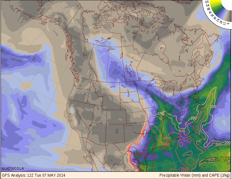
Another change over the past few decades is the development of a wider variety of remote sensing techniques for better discerning the distribution of moisture in the atmosphere. The old satellite standby, an image of water vapor, happens to focus on moisture in the middle layers of the atmosphere. It has been joined by extra satellite sensors and by other indirect techniques. All of the remote techniques have their uncertainties. Instead of trying to weigh the uncertainties myself, I rely on depictions of precipitable water (PW) as assimilated into numerical models. Specifically, I like the presentations at COLA's wxmaps.org. Their plots clearly identify key contour levels of PW. When those contours are viewed alongside the old-standby satellite water vapor image, you get some feeling for the vertical distribution of the moisture: whether it is confined mostly to the lower layers of the atmosphere, as is often the case at the very beginning of the monsoon, or whether thunderstorms on previous days have left considerable remnant moisture in the middle layers. If the moisture is mostly confined to the lower layers of the atmosphere, then 25 mm (1 inch) of PW corresponds to a daytime surface dewpoint in the mid-50's. The bottom line is that 25-30 mm of PW is the transition to the monsoon.

Although they are still far from perfect, the model assimilations and forecasts of PW are more reliable than they were a few decades ago, providing a picture of the advance of the monsoon well before it reaches the southern horizon. But once it reaches the International Border, I revert to remotely sensing out on the patio and enjoying the show.

Monday, June 6, 2011

It's Monsoonal Season

The monsoonal season has arrived in Tucson. No, not the two months or so of near daily thunderstorms; that's still about a month away. What's already in full force is the silly season of talk about the monsoon. For the next month Tucsonans will endure media and meteorologists making pronouncements regarding the monsoon in general and the upcoming season in particular.

My peeve is not with the general public. Anyone who has lived in Tucson for awhile understands what the monsoon is about, and when it arrives. It's always fun to talk about the monsoon, and to speculate about the exact date when it will start. Most years the monsoon can be relied on to start within a week of, and usually just after the 4th of July. It's fun to plan on a dry 4th, anticipating a wet 6th, 8th or 10th.

More often than not at least once before the 4th it rains enough to wet the ground in Tucson. Obviously that will be the case when the monsoon arrives early. But there are rare rain days in June or very early July caused by mid-latitude westerly troughs. Traditionally meteorologists in Tucson would emphasize that those days were not the beginning of the monsoon. Their emphasis would be based not only on a diagnosis—that the winds aloft did not come close to meeting the definition of a seasonal wind shift, but also on a forecast—that the rains would not persist right on into the monsoon.

How does the National Weather Service currently define the beginning of the monsoon? I've lost track of the changes. I think that the NWS missed an opportunity a few years ago to reestablish a distinction between the monsoon, when thunderstorms occur almost every day, versus the encompassing summer thunderstorm season, the early part of which is mostly dry but with infrequent and especially hazardous days of high-based thunderstorms.

Although it goes against tradition, there is a case to be made for counting non-persistent June thunderstorms, perhaps racing swiftly off to the east-northeast, as part of the monsoon. The argument would go like this. The associated westerly trough managed to temporarily capture part of the moisture that was pooling south of the subtropical ridge. Climatologically that ridge is in the process of moving north to it's July-August position in Arizona. Parts of Sonora, Mexico, may already be experiencing the effects of a monsoonal flow. Thunderstorms in Tucson during the mid- to late-June period are less rare than earlier in June, suggesting that the northward advance of the subtropical ridge is more relevant than the obstinacy of the westerlies. The case against: those storms are followed by extended periods with no rain.

Tucson is very different from Phoenix in a number of ways. With regard to temporary surges of moisture before the monsoon, the difference lies in the trajectories of air flowing from the west-southwest toward each city. Phoenix is more susceptible to dry air from above the cold waters of the Pacific, say just south of San Diego. Tucson has more exposure to moist air channelled through the central Gulf of California. Temporary surges of high humidity at Phoenix get scoured away within a few days. In contrast, after the initial surge, high daily-average dewpoints may linger for several days in Tucson. It might be argued that persistently high daily-average dewpoints in June, albeit not quite high enough for afternoon/evening rain in the city, should define the beginning of the monsoon. But that definition clashes with what would have been the traditional call (based in part, I re-emphasize, on forecasters making forecasts) as well as my impression of what most Tucsonans think of as "the monsoon". If the monsoon starts this year on July 6, it will not be late. It will be right on time.

Tuesday, March 29, 2011

It Was A Dry Winter

in Tucson. Last October I posted about the oncoming La Niña winter in Tucson. Included with that post was a plot meant to illustrate that, based on the previous sixty years, the then oncoming La Niña winter had a range of possibilities for total rainfall, from well-below average to just-below average. The vertical scale in that plot is the rainfall total for a five month period extending from November through March. It is now close to the end of March, so this 61st five-month winter period is almost over. We aren't going to get any more rain in the next two days. Tucson airport will have had a total of 0.73 inches for November 2010 through March 2011, making it the second lowest November-March period in the last 61 years. The lowest was just five years ago, and that winter did not quite qualify officially as a La Niña winter. This past winter's nearest dry neighbors in the moderate-to-strong La Niña category were 1970-1971, 1998-1999, and 1999-2000. You can identify those three previous winters in the plot by noting the color-coding for the decades. (Although the March sea surface temperature anomaly in the Niño 3.4 region is not yet available, the average over the five-month period should work out to about -1.25 °C.)

My rainfall total for this most recent five-month winter period was 1.64 inches, more than twice that of the airport. Five years ago, when the airport had it's driest November through March, I also had about twice what the airport had. (I don't get twice as much as the airport on average.) To some extent the driest winters at the airport are just dumb luck, with rare showers in an already dry year happening to miss the airport.

Fortunately, within a day's drive both west and north of Tucson it has been a wet winter. Colorado River water inflow to Arizona is expected above normal. The fact that demand exceeds long-term supply in Arizona won't have to be reckoned with for a few more years.

Thursday, February 24, 2011

Good Chance of Snow in Tucson Sunday Morning

The last few times before this, over the last few years, when the prospect of accumulating snow in Tucson has been played up, I have been skeptical. The most likely scenario always was for drier air to arrive with the coldest air. This time is different. Before the arctic air turns east and moves rapidly toward Tucson overnight Saturday, it will have had a long time to pick up moisture from the Pacific while hugging the California coast from San Francisco (overnight Friday) to Los Angeles (Saturday evening). The system will be moving east through Tucson rapidly on Sunday, and drier air should sweep in well before noon (per the consistent run-to-run GFS 700 mb RH progs for 18Z). And the heaviest precipitation should be all rain both in the foothills and in the valley until almost sunrise on Sunday. But there could well be a few hours of light, wet snow either side of sunrise when about a half-inch, maybe an inch average accumulates.

Thursday, February 3, 2011

Bougainvillea and Ice

I took this picture at 10 AM today, February 3, 2011. By sunset a little over half of the ice had melted. The high at TUS airport was 38F, about the same as here.
The bougainvillea looked great at Christmas. But then near the beginning of the year there were two hard freeze events that took their tolls on the leaves and flowers. So I wasn't trying to protect these branches. Instead, I have a hodgepodge of covers and wraps and Christmas lights to try to protect the lower parts of the plants. I watered them last night, and will again tonight. I'm not sure what happened to the one irrigation line. It must have frozen during the night, and began spraying a fine mist straight up. The wind carried the mist onto these branches. In the top middle of the picture, against the brick background, you can see streaks of the airborne droplets.
It looks like the brunt of the next arctic outbreak will stay east of the Continental Divide. At least I hope so. But next week once again I'll have a wary eye on the weather stations along the I-80 corridor in Southern Wyoming for the first confirmation of sure trouble.

Thursday, January 13, 2011

My Thoughts

Reflecting on a trait that I admired in one of the Tucson victims with whom I was slightly acquainted, I keep reminding myself to work at trying to be respectful of everyone, all the time, no exceptions. That includes the people I agree with, people I disagree with, Christians, Muslims, atheists, good drivers, slow drivers, distracted drivers, sane people, and people who may be on the edge.
It's the nature of politicians to point out the absurdity in their opponent's position. There's no disrespect in that. Comedians and entertainers point out absurdities all the time; they have a lot of material to work with in the political discourse. The real disrespect starts when evil motivations are ascribed to an opposing position. That angle of attack could be seen merely as a humorous way of making a point, as long as everyone is laughing. But I don't think that is always the case. The rhetoric easily deteriorates into our side against the evil other side, with the other side undeserving of respect.
It's understandable that some prominent people have taken umbrage at the remarks by our Sheriff, Clarence Dupnik. If those people were to drop their me against evil shtick, they wouldn't have anything left. I hope most people will agree with the words of the President last night.